
The Shaky Ground: An In-depth Report on the Top 5 Most Earthquake-Prone Countries
Introduction: Our planet is alive, its surface a mosaic of colossal tectonic plates in perpetual motion. Where these plates grind, collide, or pull apart, the ground trembles. While nearly every country experiences some level of seismic activity, a few sit at the very epicenters of this geological drama. This report identifies the top five countries that endure the most frequent and intense earthquakes. This ranking is based not just on the sheer number of minor tremors, but on a combination of frequency, magnitude, and the complexity of the tectonic environment. Unsurprisingly, the notorious “Ring of Fire” dominates this list.
1. Japan: The Unforgiving Frontier
| Key Data | |
|---|---|
| Tectonic Setting | Intersection of four major plates: Pacific, Philippine Sea, Eurasian, and North American. |
| Annual Earthquakes (Felt) | Over 1,500 per year. |
| Notable Quakes | 2011 Tōhoku (Mw 9.1), 1923 Great Kantō (Mw 7.9), 1995 Great Hanshin (Mw 6.9) |
| Preparedness Level | World-Leading. Advanced early warning, strict building codes, and public drills. |
In-depth Analysis
Japan is arguably the most seismically active country in the world. It sits precariously atop the convergence point of four major tectonic plates. This complex intersection makes the archipelago susceptible to every type of earthquake: powerful “megathrust” quakes where one plate subducts under another, and destructive shallow quakes from crustal faults. The 2011 Tōhoku earthquake was a brutal reminder of the megathrust threat, unleashing a devastating tsunami.
 (Image: A map illustrating the high density of earthquakes around Japan, directly correlating with the complex tectonic plate boundaries.)
In response to this constant threat, Japan has become the global gold standard for earthquake resilience. Its investment in a nationwide Earthquake Early Warning (EEW) system provides seconds to minutes of alert before strong shaking arrives. Its building codes are among the strictest in the world, mandating technologies like base isolation and vibration control to allow skyscrapers to sway safely. This culture of preparedness, ingrained from childhood, is a critical defense against a geological reality that shows no mercy.
2. Indonesia: The Archipelago on the Edge
| Key Data | |
|---|---|
| Tectonic Setting | Convergence of the Indo-Australian, Eurasian, and Pacific plates. |
| Annual Earthquakes (Total) | Tens of thousands, with hundreds being felt. |
| Notable Quakes | 2004 Sumatra-Andaman (Mw 9.1), 2018 Sulawesi (Mw 7.5), 2006 Yogyakarta (Mw 6.3) |
| Preparedness Level | Improving but challenged. Vast geography and economic disparities create uneven resilience. |
In-depth Analysis
Indonesia is a sprawling archipelago of over 17,000 islands, straddling the most active part of the Ring of Fire. The Indo-Australian plate is actively subducting beneath the Eurasian plate to the west and south, while the Pacific plate pushes from the east. This creates a zone of immense volatility, responsible for some of the largest earthquakes ever recorded, including the 2004 Sumatra-Andaman quake that triggered the catastrophic Indian Ocean tsunami.
 (Image: Aerial view of the destruction in Palu, Central Sulawesi, following the 2018 earthquake, which also caused liquefaction and a tsunami.)
The country’s sheer size and developing economy present immense challenges for disaster management. While major urban centers may have stricter building codes and better response capabilities, thousands of remote islands and coastal communities are highly vulnerable. The 2018 Sulawesi earthquake highlighted a compound disaster risk: the quake triggered a tsunami and a rare phenomenon called soil liquefaction, where solid ground behaves like a liquid, swallowing entire neighborhoods. Indonesia’s ongoing struggle is to scale up its preparedness and infrastructure to match the scale of its geological risk.
3. Chile: The Land of Superquakes
| Key Data | |
|---|---|
| Tectonic Setting | Subduction of the Nazca Plate beneath the South American Plate. |
| Annual Earthquakes (Significant) | Dozens of strong (Mw 5.0+) quakes per year. |
| Notable Quakes | 1960 Valdivia (Mw 9.5 - The strongest ever recorded), 2010 Maule (Mw 8.8), 2015 Illapel (Mw 8.3) |
| Preparedness Level | High. Strict building codes and a population accustomed to seismic events. |
In-depth Analysis
If Japan is defined by frequency, Chile is defined by raw power. The entire country is wedged against a massive subduction zone where the oceanic Nazca plate plunges beneath the continental South American plate. This process builds up incredible energy, which is released in the form of “superquakes.” Chile has experienced more earthquakes of magnitude 8.0 or larger than any other country. The 1960 Valdivia earthquake, at a staggering magnitude 9.5, remains the most powerful seismic event ever recorded by modern instruments.
 (Image: The coastal uplift near Constitución, Chile, where the land was raised by several meters during the 2010 Maule earthquake.)
Living with this constant threat has forged a culture of seismic awareness. Chile’s building codes are famously strict, having been refined over a century of powerful quakes. Structures are designed to be flexible, allowing them to sway without collapsing. While the 2010 Maule earthquake revealed weaknesses in some newer constructions, overall, the country’s preparedness has saved countless lives. Chile’s experience demonstrates that it is possible to thrive in one of the most violent earthquake zones on Earth through engineering and vigilance.
4. United States: The Two-Front Threat
| Key Data | |
|---|---|
| Tectonic Setting | Alaska: Subduction zone (Pacific Plate under N. American). California: Transform boundary (Pacific & N. American Plates). |
| Annual Earthquakes (Significant) | Alaska: Thousands, many over Mw 5.0. California: Hundreds, with a major (Mw 7.0+) expected. |
| Notable Quakes | 1964 Alaska (Mw 9.2), 1906 San Francisco (Mw 7.9), 1994 Northridge (Mw 6.7) |
| Preparedness Level | Advanced but regionally variable. High-tech monitoring (USGS), but inconsistent building codes and public awareness. |
In-depth Analysis
The United States faces a two-pronged seismic threat, primarily from Alaska and California. Alaska is part of the Ring of Fire and experiences more earthquakes than the other 49 states combined. The 1964 Great Alaska Earthquake (Mw 9.2) was the second-most powerful ever recorded. However, its low population density means the impact is often less catastrophic than in other regions.
 (Image: The San Andreas Fault, a classic transform fault, stretching across California’s Carrizo Plain.)
The more widely known threat lies in California, where the Pacific and North American plates grind past each other via the famous San Andreas Fault system. This “transform boundary” doesn’t typically produce the world’s largest quakes, but it poses a direct threat to tens of millions of people and critical infrastructure. The U.S. benefits from world-class scientific monitoring by the U.S. Geological Survey (USGS) and advanced research centers like the ShakeAlert early warning system. However, preparedness is a patchwork of state and local regulations, and a major earthquake on an urban fault could still be one of the most expensive natural disasters in U.S. history.
5. China: The Collision Zone
| Key Data | |
|---|---|
| Tectonic Setting | Collision of the Indian Plate with the Eurasian Plate, plus eastern fault systems. |
| Annual Earthquakes (Significant) | Hundreds of earthquakes over Mw 4.0 per year. |
| Notable Quakes | 2008 Wenchuan (Mw 7.9), 1976 Tangshan (Mw 7.8), 2020 Sichuan (Mw 7.0) |
| Preparedness Level | Rapidly improving. Significant investment in monitoring and engineering post-2008, but enforcement remains a challenge. |
In-depth Analysis
China’s seismic risk is driven by the immense tectonic force of the Indian plate crashing into the Eurasian plate. This slow-motion collision, which built the Himalayas, creates intense stress across a vast swath of the country’s western and central regions. This is not a simple Ring of Fire subduction zone but a complex “collision zone” with numerous active faults capable of producing devastating earthquakes, like the 2008 Wenchuan disaster.
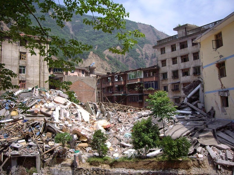 (Image: The ruins of Beichuan County, destroyed by the 2008 Wenchuan earthquake, highlighting the vulnerability of towns in mountainous regions.)
Historically, building standards in many vulnerable areas were low, leading to catastrophic loss of life. The 2008 Wenchuan earthquake was a national wake-up call. In its aftermath, China invested heavily in its earthquake monitoring network, launched a massive program to retrofit and reinforce schools and hospitals, and significantly updated its seismic building codes. While enforcement across such a vast and populous nation remains a challenge, China has made a decisive pivot towards building a more resilient society in the face of its inescapable geological fate.
Conclusion: Living with the Unavoidable
The top five most earthquake-prone nations share a common thread: they sit on the world’s most violent tectonic boundaries. Yet, their stories are not just of geological suffering, but of human adaptation.
From Japan’s high-tech vigilance and Chile’s hardened infrastructure to the ongoing struggles and rapid progress in Indonesia and China, the lesson is clear. We cannot stop the ground from shaking, but we can control how we build upon it and how we prepare for the inevitable. The “shaky ground” is a permanent feature of our planet, and for these nations, the quest for resilience is a continuous, unending, and vital endeavor.