
Scars of History: An In-depth Report on the 10 Most Destructive Earthquakes in Recorded History
Introduction: The pulse of the Earth is sometimes a fatal spasm. Earthquakes, as one of nature’s most destructive forces, have left countless profound scars on the long river of human history. To measure the “destructiveness” of an earthquake, magnitude (Richter or Moment Magnitude) is the scientific yardstick. However, the death toll, economic losses, social impact, and the shock to human civilization better reflect its brutal reality. This report will primarily rank these events by death toll, combined with magnitude, secondary disasters, and historical impact, to provide an in-depth analysis of the ten most destructive earthquakes in history.
1. The 1556 Shaanxi Earthquake (Huaxian, China)
“The number of people crushed to death is unknown.” — History of Ming, Treatise on the Five Elements
| Key Data | |
|---|---|
| Date | January 23, 1556 |
| Location | Shaanxi, Shanxi, and Henan Provinces, China |
| Magnitude | Estimated ~Mw 8.0 to 8.3 |
| Death Toll | ~830,000 (Deadliest earthquake in recorded history) |
| Primary Forms of Destruction | Widespread collapse of loess cave dwellings, landslides, ground fissures |
In-depth Analysis
The reason for the unprecedented devastation of this earthquake, known historically as the Jiajing Great Earthquake, was the vulnerability of human settlements. At the time, residents in Shaanxi, Shanxi, and other regions commonly lived in cave dwellings carved into loess cliffs. While these homes were warm in winter and cool in summer, their seismic resistance was virtually non-existent. When the earthquake struck, violent shaking caused countless caves to collapse instantly, burying people in their sleep. Records indicate the earthquake affected an area of 900,000 square kilometers, with its tremors felt over half of China.
 (Image: Map illustrating the intensity and death toll distribution of the 1556 Shaanxi earthquake. No photographs exist from this era.)
Beyond the direct casualties, the ensuing famine, plagues, and social turmoil prolonged the disaster’s impact for years. It served as a bloody lesson: architectural quality is the first line of defense for life during an earthquake.
2. The 1976 Tangshan Earthquake (Hebei, China)
| Key Data | |
|---|---|
| Date | July 28, 1976, at 3:42 AM |
| Location | Tangshan, Hebei Province, China |
| Magnitude | Ms 7.8 (Epicentral intensity: XI) |
| Death Toll | Official figure: 242,000; estimates by scholars: up to 655,000 |
| Primary Forms of Destruction | City utterly flattened, railways twisted, bridges collapsed |
In-depth Analysis
The Tangshan earthquake, the second-deadliest of the 20th century, was devastating due to its cataclysmic impact on a major industrial city of over one million people. The quake struck in the early morning when most residents were asleep and unprepared. As buildings of the era largely lacked seismic design, brick-and-concrete structures collapsed like toy blocks, turning the entire city into ruins in mere seconds.
 (Image: The aftermath in Tangshan, showing the complete destruction of urban buildings.)
The earthquake severed all transportation, communication, and power lines, turning Tangshan into an isolated island. The disaster not only caused immense casualties but also crippled China’s industrial heartland. Against the special historical backdrop of the Cultural Revolution, Tangshan’s rescue and reconstruction were fraught with hardship, but it also ignited the national spirit of “When one place is in trouble, assistance comes from all sides,” becoming a pivotal moment in modern Chinese disaster relief history.
3. The 2004 Indian Ocean Earthquake and Tsunami (Sumatra, Indonesia)
| Key Data | |
|---|---|
| Date | December 26, 2004 |
| Location | Off the coast of Sumatra, Indonesia |
| Magnitude | Mw 9.1 to 9.3 (3rd strongest earthquake ever recorded) |
| Death Toll | ~230,000 (across 14 countries) |
| Primary Forms of Destruction | Unprecedented trans-oceanic tsunami, earthquake |
In-depth Analysis
The destructiveness of this disaster stemmed primarily from the unprecedented trans-oceanic tsunami it triggered. The megaquake, with an energy release equivalent to thousands of atomic bombs, generated colossal waves up to 30 meters high that raced across the Indian Ocean at 800 km/h. From Indonesia to Sri Lanka, Thailand to India, and even as far as the east coast of Africa, devastation was total.
 (Image: Aerial view of coastal destruction in Banda Aceh, Sumatra, following the tsunami.)
The Indian Ocean region lacked a tsunami warning system at the time, leaving coastal residents completely unaware of the impending danger after the initial quake. This global catastrophe led to the establishment of the Indian Ocean Tsunami Warning and Mitigation System by the UN and national governments, marking a milestone in humanity’s learning from tragic lessons.
4. The 2010 Haiti Earthquake
| Key Data | |
|---|---|
| Date | January 12, 2010 |
| Location | Near Port-au-Prince, Haiti |
| Magnitude | Mw 7.0 |
| Death Toll | Estimates range from 100,000 to 316,000 (highly contested data) |
| Primary Forms of Destruction | Widespread collapse of extremely poor-quality buildings, infrastructure paralysis |
In-depth Analysis
The destructiveness of the Haiti earthquake was not in its magnitude, but in the extreme social vulnerability of the nation. As the least developed country in the Western Hemisphere, Haiti suffered from chronic poverty, political instability, and weak governance. Buildings were largely constructed without seismic codes, often using substandard materials. A 7.0-magnitude quake might cause limited damage in a well-prepared nation, but in Haiti, it destroyed the Presidential Palace, the UN headquarters, hospitals, and schools—all critical infrastructure.
 (Image: The Presidential Palace in Port-au-Prince, a symbol of the nation’s collapse.)
The capital, Port-au-Prince, was almost completely paralyzed, and rescue efforts were hampered by the breakdown of infrastructure. The Haiti earthquake is a stark case study revealing that behind a natural disaster often lies a man-made catastrophe—poverty and failed governance are catalysts that amplify a disaster’s impact.
5. The 1923 Great Kantō Earthquake (Japan)
| Key Data | |
|---|---|
| Date | September 1, 1923, at 11:58 AM |
| Location | Kantō region, Japan (centered on Tokyo and Yokohama) |
| Magnitude | Ms 7.9 |
| Death Toll | ~140,000 |
| Primary Forms of Destruction | Massive firestorms triggered by the quake, tsunami, landslides |
In-depth Analysis
The destructiveness of the Great Kantō Earthquake was massively amplified by its secondary disaster—fire. The quake struck at noon, when many families were cooking with open flames. The violent shaking overturned stoves, igniting the wooden houses common at the time. Simultaneously, the earthquake destroyed the water mains, rendering firefighters powerless. The fires quickly spread, coalescing into gigantic “firestorms” that killed more people through heat and asphyxiation than the quake itself.
 (Image: A massive firestorm engulfs the Honjo district of Tokyo after the 1923 earthquake.)
In Tokyo and Yokohama, tens of thousands were burned or suffocated. Furthermore, the disaster was followed by massacres against Korean and Chinese residents in Japan, a dark chapter in the nation’s history. The Great Kantō Earthquake prompted Japan to promote fire-resistant construction and urban disaster planning during its reconstruction, profoundly shaping modern Tokyo.
6. The 2008 Wenchuan Earthquake (Sichuan, China)
| Key Data | |
|---|---|
| Date | May 12, 2008, at 2:28 PM |
| Location | Wenchuan County, Sichuan Province, China |
| Magnitude | Ms 8.0 (Mw 7.9) |
| Death Toll | 69,227 dead, 374,643 injured, 17,923 missing |
| Primary Forms of Destruction | Massive landslides and rockfalls, building destruction, formation of “quake lakes” |
In-depth Analysis
The Wenchuan earthquake’s destructiveness was defined by its complex geological environment and the secondary disasters it triggered. The epicenter was on the Longmenshan Fault, a region of high topographical relief with deep valleys and towering mountains. The intense shaking triggered tens of thousands of landslides and rockfalls, burying countless villages and roads and completely destroying towns like Beichuan.
 (Image: A massive landslide near the epicenter, captured by NASA. The white scar is the debris flow.)
The earthquake also created over 30 massive “quake lakes,” which posed a constant threat to millions downstream. During this disaster, the widespread collapse of school buildings became a focal point of national concern, sparking deep reflection and accountability regarding construction quality. The Wenchuan earthquake was the most impactful natural disaster for China since the Reform and Opening-Up, greatly advancing the nation’s emergency response system.
7. The 1908 Messina Earthquake (Italy)
| Key Data | |
|---|---|
| Date | December 28, 1908, at 5:21 AM |
| Location | Strait of Messina, Italy |
| Magnitude | Ms 7.1 |
| Death Toll | ~75,000 to 120,000 |
| Primary Forms of Destruction | Earthquake followed by a devastating tsunami, near-total destruction of cities |
In-depth Analysis
This earthquake almost wiped Messina, Sicily’s third-largest city, and Reggio Calabria on the mainland off the map. Minutes after the quake, a tsunami up to 12 meters high swept the coastlines of both cities, engulfing survivors and debris. The buildings of the era, mostly masonry structures, had no seismic resistance and were pulverized by the strong shaking. The disaster struck in the early morning when most people were indoors, resulting in catastrophic casualties.
 (Image: The complete devastation of Messina’s city center.)
The Messina earthquake was the deadliest natural disaster in 20th-century Europe and prompted the Kingdom of Italy to enact its first national seismic building code during the reconstruction, setting a precedent for seismic legislation in Europe.
8. The 1970 Ancash Earthquake (Peru)
| Key Data | |
|---|---|
| Date | May 31, 1970 |
| Location | Ancash Region, Peru |
| Magnitude | Ms 7.9 |
| Death Toll | ~70,000 |
| Primary Forms of Destruction | Triggered the deadliest avalanche/landslide in history |
In-depth Analysis
The destructiveness of the Ancash earthquake was concentrated in the super-landslide it triggered. The earthquake destabilized the glacier and rock on the north peak of the 6,721-meter-high Huascarán mountain. This caused approximately 80 million cubic meters of ice, rock, and mud to careen down the valley at speeds up to 400 km/h, completely burying the towns of Yungay and parts of Ranrahirca below.
 (Image: The former location of Yungay, now buried under a field of debris from the Huascarán landslide. The palm trees in the center were part of the town’s plaza.)
The force of the landslide was equivalent to several nuclear bombs; its speed and scale were unimaginable. Yungay’s original population of 20,000 was almost entirely wiped out. This catastrophe highlighted the critical importance of assessing and preventing secondary geological disasters in seismically active and topographically complex mountainous regions.
9. The 2011 Tōhoku Earthquake (Japan)
| Key Data | |
|---|---|
| Date | March 11, 2011, at 2:46 PM |
| Location | Off the Pacific coast of Tōhoku, Japan |
| Magnitude | Mw 9.0–9.1 (Strongest earthquake in Japan’s recorded history) |
| Death Toll | ~20,000 (combined dead and missing) |
| Primary Forms of Destruction | Massive tsunami, nuclear meltdowns |
In-depth Analysis
The destructiveness of the Tōhoku earthquake was complex and modern. While its death toll (~20,000) is not the highest on this list, its impact is profound and multifaceted. First, the Mw 9.0 megaquake generated colossal waves up to 40 meters high. The tsunami breached Japan’s famed seawalls, inundating vast coastal areas.
 (Image: a large ship sits atop a building in Miyagi prefecture, a testament to the tsunami’s power.)
Second, the tsunami caused a station blackout at the Fukushima Daiichi Nuclear Power Plant, leading to cooling system failures and ultimately the worst nuclear disaster since Chernobyl, with massive releases of radioactive material. This catastrophe thrust the issue of “nuclear safety” into the global spotlight and prompted many nations to reconsider their energy policies.
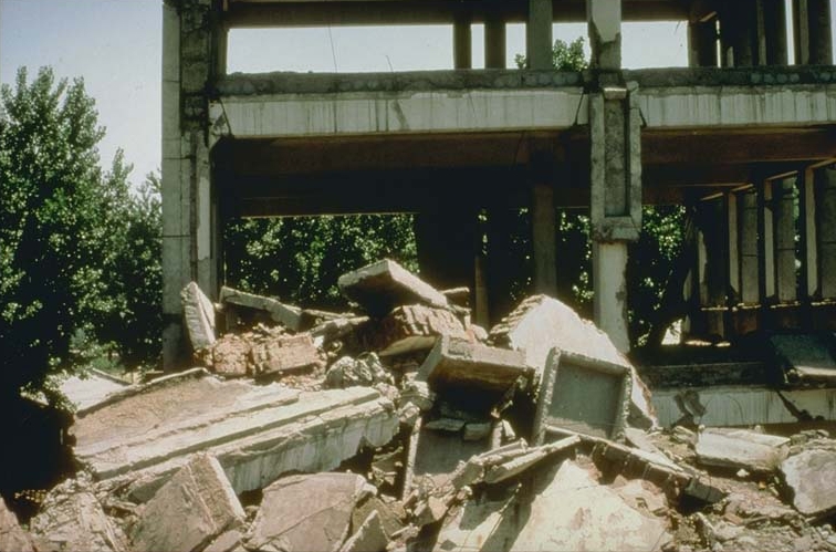
10. The 2023 Turkey–Syria Earthquake
| Key Data | |
|---|---|
| Date | February 6, 2023, at 4:17 AM |
| Location | Gaziantep Province, Turkey, and Northern Syria |
| Magnitude | Mw 7.8 (mainshock), followed by a Mw 7.5 aftershock 12 hours later |
| Death Toll | Over 59,000 (combined in Turkey and Syria) |
| Primary Forms of Destruction | Widespread building collapse, relentless aftershocks, difficult cross-border aid |
In-depth Analysis
This earthquake was the fifth-deadliest of the 21st century. Its destructiveness lay in a combination of high magnitude, shallow depth, a powerful aftershock, and occurrence in a densely populated region. The 7.8-magnitude mainshock caused immense devastation, but the 7.5-magnitude strong aftershock on a nearby fault just 12 hours later compounded the destruction, causing countless already-damaged buildings to collapse completely.
 (Image: A multi-story residential building in Kahramanmaraş that suffered a “pancake” collapse.)
The quake struck during the cold early morning hours, leaving survivors facing frostbite and hypothermia. Compounding the tragedy, the disaster zone straddled Turkey and Syria. In northern Syria, prolonged civil war obstructed humanitarian aid corridors, making rescue efforts exceptionally difficult. The earthquake once again exposed the lax enforcement of building codes in parts of Turkey and highlighted the extreme challenges of disaster relief in conflict zones.
Conclusion: Drawing Strength from the Scars of History
Reviewing these ten shocking disasters, we can identify several common patterns:
- Construction is Key: From the loess caves of Shaanxi to the slums of Haiti and the brick buildings of Tangshan, the fragility of structures is the primary cause of mass casualties.
- Secondary Disasters are Force Multipliers: Tsunamis, fires, landslides, quake lakes, and nuclear meltdowns often prove more deadly than the quake itself.
- Timing and Context are Critical Factors: Early morning or midday, densely populated areas, and impoverished or conflict-ridden regions all multiply the consequences of a disaster.
- Early Warning and Preparedness are Life-or-Death: The lesson of the 2004 Indian Ocean Tsunami led to the creation of a warning system, and Japan’s frequent disaster drills have saved countless lives.
The Earth’s tectonic plates are in perpetual motion; earthquakes cannot be predicted, but their destruction can be mitigated. The scars of history, visible in these photographs, constantly remind us: we must revere nature, respect science, reinforce our buildings, improve our systems, and enhance every individual’s awareness of disaster prevention. Only then, when the Earth’s next pulse beats violently, can we better protect ourselves and the civilization we cherish.